Saturday, July 17, 2010
Day 8
Well, today was more than relaxing. We slept in until 9:00 am. After lazying around for a while we went to town, had lunch, and walked around the shops. The only fun thing there is a shopping story. While I have been here I keep saying, "it must be the altitude". Well, while shopping today I found a visor that says it! With the altitude you get tipsy quicker, out of breath quicker and feel tired faster. After shopping I came back to the room and took a nap. Then, we went swimming in the hot springs. The hot springs has 3 different pools ranging from 102, 97, and 85 degrees. It felt great on my sore muscles from my fall yesterday. We brought dinner back and ate it outside. Now, I'm catching up on internet stuff and plan to label all of my pictures before I forget what everything is. Tomorrow we go to Box Canyon and I have my hiking stick ready!

Friday, July 16, 2010
Day 7
Day 7 and I am in Heaven!! Let me put a disclaimer out there: Our internet is REALLY slow so I am not going to put up pictures for the next few days on the blog. However, they are on facebook so feel free to check them out there. I hope our internet connection is good enough for me to put captions up today. Today we got to sleep in an hour before starting our adventure. First, we drove up The Million Dollar Highway, which is a VERY curvy road up and down the mountains. It is called this because it cost $1 Million to build one mile. After surviving the way to Silverton, we explored the The Old 100 Gold Mine. Unfortunately, we didn't find any gold so I am not rich. Darn! After that we explored the town and saw an old time train, which I didn't get a picture of because for once, I did not bring my camera. On the way back to Ouray we stopped at a few placed to look at geological features. At one of them, I managed to find the one part of the sidewalk that was missing and fell. Apparently I was graceful and I managed to protect my precious camera and scraped my elbow. :( Tonight we went downtown and I bought a walking stick for our hikes, which will hopefully help some. I needed it today on the sidewalk. My major point of excitement today was finding a rock and being able to identify it! GO ME!!! Alrighty, my laundry is done. Tomorrow is our free day in town so I will let you know what adventure we come up with.
Thursday, July 15, 2010
Today was a pretty chill day and I loved every minute of it. First, we stopped at the Dallas Divide and looked at the effect of glaciers on the land’s surface. We also found out that we were standing on the boundaries of Ralph Lauren’s ranch. Upon this announcement one girl said, “That’s my future ex-husband” and everyone was slightly shocked. She then replied with, “What? I’m just being realistic?”
After that we went to Telluride, a ski resort town with the cutest shops and some fantastic landforms. We rode the Gondola up to Mountain City and explored the various trails. Then, we went to lunch at the Sheritan Hotel and had some pretty good Mac and Cheese. I can’t say it’s the BEST but it was pretty darn good. After lunch we explored an area that had some waterfalls and a mining area. Then, we had our real adventure! We explored the stream and measured the velocity of the water. The water was FREEZING!!It was pretty cool to do a small portion of studies that geologists do. Then, we dyed the water so we could see the flow of the water. The water came up to my knees but it was a lot of fun!
After Telluride, we drove to Ouray, our home for the next 4 days. It is very beautiful here and I would love to come here again! We went to a Mexican restaurant and it was delicious! Our room is amazing!! We have two doors, 2 kind size beds, electric fireplace, a balcony overlooking the river, and tons of western themed décor! Apparently bears are a problem here so we are hopeful that we will actually see a bear, from a distance of course. I will continue to keep you posted on our journeys. I apologize that I don’t have any pictures today but I have a really bad connection. Feel free to check facebook for some photos.
After that we went to Telluride, a ski resort town with the cutest shops and some fantastic landforms. We rode the Gondola up to Mountain City and explored the various trails. Then, we went to lunch at the Sheritan Hotel and had some pretty good Mac and Cheese. I can’t say it’s the BEST but it was pretty darn good. After lunch we explored an area that had some waterfalls and a mining area. Then, we had our real adventure! We explored the stream and measured the velocity of the water. The water was FREEZING!!It was pretty cool to do a small portion of studies that geologists do. Then, we dyed the water so we could see the flow of the water. The water came up to my knees but it was a lot of fun!
After Telluride, we drove to Ouray, our home for the next 4 days. It is very beautiful here and I would love to come here again! We went to a Mexican restaurant and it was delicious! Our room is amazing!! We have two doors, 2 kind size beds, electric fireplace, a balcony overlooking the river, and tons of western themed décor! Apparently bears are a problem here so we are hopeful that we will actually see a bear, from a distance of course. I will continue to keep you posted on our journeys. I apologize that I don’t have any pictures today but I have a really bad connection. Feel free to check facebook for some photos.
Wednesday, July 14, 2010
Day 5 and I am still alive!!


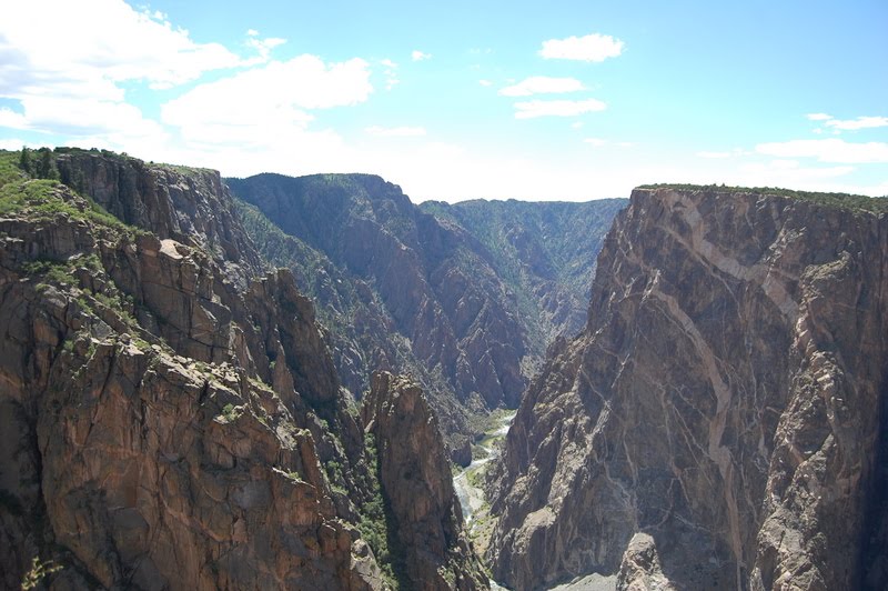


Okay, here are a few random stories for you. Don't you love random? I do! I learned that Trinidad,CO (where we stayed a few nights ago) is the sex change capital of the world. We found that out on the way out of town. I have seen several Gators on the trip. Mostly today. At Monarch Pass I saw an old couple and the man was wearing a Gator polo and I of course pulled the Shands commercial, "Go Gators". Of course, I am a talker and that turned into a conversation. They just moved to CO from Gainesville, Fl and their son just moved from Gainesville to Texas, which I thought was pretty cool. Then, when we were at Black Canyon and I saw a truck with a Florida plate and Gator something on their car. I then went around asking for the Gator fans but never found them. :(
Before coming on this trip I heard about how this was going to be a life changing experience. The first few days all I could think was, "how on Earth is this life changing". We would joke about not being able to make it back to the bus after walking all over the world and how it would be life changing. However, I really am starting to understand what they are talking about. I will never look at landforms the same. I have already learned so much on this trip and I still have 10 days to go.
Tuesday, July 13, 2010
G Camp Day 4


In this photo I just got done using my handy dandy rock hammer to knock out some rhyalite from this dike. There were a lot of these on our journey today.


This picture contains Mount Mestus and another mountain that I can't remember the name of. :) One of our tour guides, Rick completed his Ph.D work on this mountain. 
About 20 minutes from the last accident, we saw another one! Needless to say, I have been a nervous wreck on the bus and I forgot my Xanax. At least our bus driver is the same one they have had for the past few years and they keep asking him to come back so he is keeping everybody safe.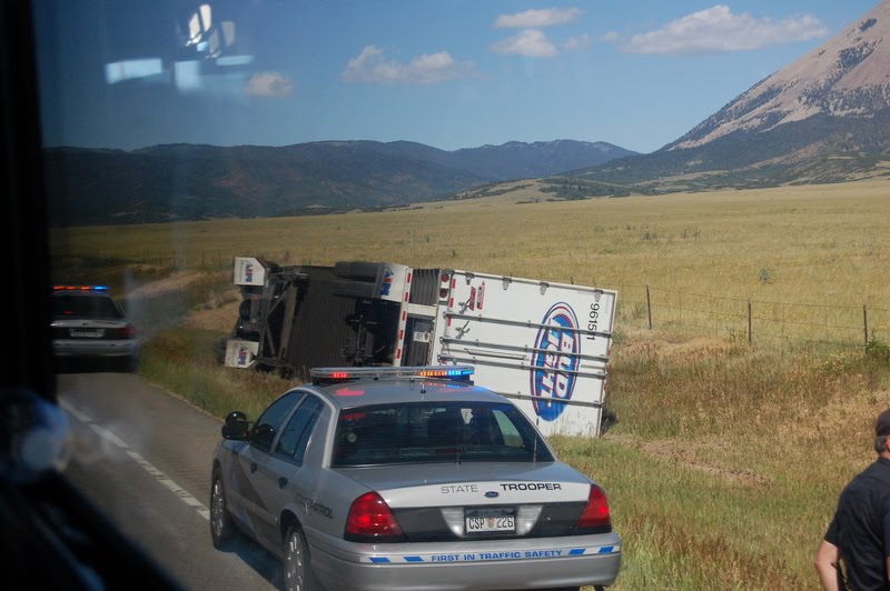


I didn't post this yesterday but last night's hotel had pretty much the same view. A parking lot. At least the weather is gorgeous here. Cristina and I decided to stay in tonight and relax our bodies. They were pretty sore. The pizza was the best decision ever and beat fast food or walking to town. More fun adventures for you tomorrow!
Monday, July 12, 2010
G Camp Day 3

Wow! Today was a busy day! We left Vernon, TX at 7 am and started our route to Trinidad, CO. On our way there we saw a small windmill farm and I managed to get a few pictures from the bus, so don't mind the glare.
 We still had a few lectures to cover so Rick went over some information on Igneous Rocks and Environments. I thought I would show you how our "Lecture on Wheels" sessions go. :)
  Along the way we saw "Rabbits Ear Peak" which has an interesting story. Short version: Settlers from Oklahoma would use that to gauge their distance to Texas. Apparently, if you go to the backside of the peak you can see wagon wheel ridges still in the ground. The "mountains" we saw today are actually a result of volcano activity, which I thought was pretty cool. I always think of volcanoes in the ring of fire, not in the middle of the continental US.
 Here is Mount Capulin Volcano. I climbed to the top, walked the rim and climbed into the bottom!! Holy Cow! I got some exercise today. Capulin is a cinder cone and has not erupted in 30,000 years. However, you can still see the rocks that resulted from the eruption and see the lava flows, which are VERY cool! So, we asked the park ranger which way to take and she suggested to go to the left. She said it was a steep walk up but an easy walk down. Man! She was not kidding. I never felt so nauseous from walking in my life! I'm sure the altitude change didn't help much.
  I finally made it to the top!! It was so amazing to see all of Earth around me and the amazing land forms, volcanic flows, critters and butterflies.... HUGE butterflies. They wouldn't stay still long enough for me to get a good picture, which made me sad but I managed. I couldn't get a picture of the butterflies, but at the top of the mountain there were tree trunks and branches COVERED in ladybugs! It was unbelievable!
  On my Picture a day blog, I will display another one of my favorite pictures from today. Hint: It has to do with ladybugs!
 Here I am with some Scoria (I think), a type of Volcanic rock. This rock was all over the place, around the rim, inside, and throughout the surrounding area. I even have a few pieces that we picked up (not in the National Park) for my own collection.
 I just thought this was a fun picture for you. Cristina and I never stayed on the trail. We did whatever we had to do to get the perfect picture. At this point we were traveling down the volcano so I was feeling good. :) After Capulin, we traveled about 10 miles further to the K-T Boundary. At this area you can see the difference in rock from the Cretaceous period and the Tertiary period. It marks the end of the Mesozoic and beginning of the Cenozoic, which is associated with the mass extinction event that wiped out the dinosaurs, which is why we have the black layer between.
  Here is a picture of the Boundary and the black part is actually coal. The rocks on top are younger and progress to older rocks. The black rock is considered the Tertiary period.
This picture displays cross sectional cuts. I will tell you more about this later! I hope you are enjoying the blog as much as I am enjoying G Camp. My random "fact" that I learned today is that we should not say that Earth or any part of it behaves a certain way because this is Geology... not Psychology. We should say it responds. Everything that happens has a scientific explanation. I have a lot of reading so I am going to get to that before I fall asleep. Feel free to leave comments!!
Sunday, July 11, 2010
P.S. Day 2
Here are some random things I learned today.
1. Never refer to Earth as "The Earth". We don't say "The Mars". It is a proper noun.
2. Donkeys are kept in cow pastures to keep coyotes away.
3. A lady that is traveling with us was an Houston Oilers cheerleader back in the day.
4. Another lady was part of the first class of women accepted to Texas A&M.
5. And... another lady was the first woman to receive a sports scholarship to Texas A&M.
6. Finally, teachers LOVE to hear their own voice!
1. Never refer to Earth as "The Earth". We don't say "The Mars". It is a proper noun.
2. Donkeys are kept in cow pastures to keep coyotes away.
3. A lady that is traveling with us was an Houston Oilers cheerleader back in the day.
4. Another lady was part of the first class of women accepted to Texas A&M.
5. And... another lady was the first woman to receive a sports scholarship to Texas A&M.
6. Finally, teachers LOVE to hear their own voice!
Subscribe to:
Posts (Atom)